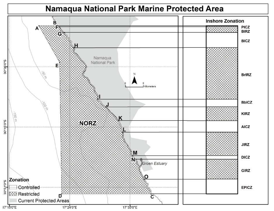


National Environmental Management: Protected Areas Act, 2003 (Act No. 57 of 2003)RegulationsManagement of the Namaqua National Park Marine Protected Area RegulationsAnnexure 1 : Zonation of the Namaqua National Park Marine Protected Area |
| (1) | Namaqua National Park Offshore Restricted Zone (NORZ) comprises the area from the line 200m seawards from the high-water mark from point Q, south of the Spoeg River, to offshore point A, south to point E, southwest to point D and east to the line 200m seawards from the high-water mark at point P at Eiland Punt. The last line links point P northwards to the first point Q along the coast at the line 200 m seawards from the high-water mark. |
| (2) | Namaqua National Park Inshore Restricted Zones: |
| (a) | Groenrivier Inshore Restricted Zone (GIRZ), stretches from point O south of the lighthouse along the high-water mark to point N north of the Groenriver mouth and 200m seawards from the high-water mark. |
| (b) | Jaar se baai Inshore Restricted Zone (JIRZ), stretches from point M north of Delwerskamp along the high-water mark to point L and 200m seawards from the high-water mark. |
| (c) | Kwas se baai Inshore Restricted Zone (KIRZ), stretches from points K to J along the high-water mark and 200m seawards from the high-water mark. |
| (d) | Bitterrivier Inshore Restricted Zone (BrIRZ), stretches from points I to H along the high-water mark and 200m seawards from the high-water mark. |
| (e) | Boulderbaai Inshore Restricted Zone (BIRZ), stretches from points G to F along the high-water mark and 200m seawards from the high-water mark. |
| (3) | Namaqua National Park Inshore Controlled Zones : |
| (a) | Eiland Punt Inshore Controlled Zone (EPICZ), stretches from point C at Eiland Punt along the high-water mark to point O south of the lighthouse and 200m seawards from the high-water mark. |
| (b) | Delwerskamp Inshore Controlled Zone (DICZ), stretches from point N north of Groenrivier mouth along the high-water mark to M and 200m seawards from the high-water mark. |
| (c) | Abjoel Inshore Controlled Zone (AICZ), stretches from point L to K along the high-water mark and 200m seawards from the high-water mark. |
| (d) | Bamboeskamp Inshore Controlled Zone (BbICZ), stretches from point J to I along the high-water mark and 200m seawards from the high-water mark. |
| (e) | Boulderbaai Inshore Controlled Zone (BICZ), stretches from point H to G along the high-water mark and 200m seawards from the high-water mark. |
| (f) | Policemans helmit Inshore Controlled Zone (PICZ), stretches from point F to B along the high-water mark and 200m seawards from the high-water mark. |
